 Border Route Trail
About
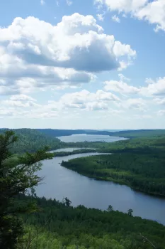
The Border Route Trail is a 65-mile long wilderness hiking trail that crosses the Boundary Waters Canoe Area Wilderness (BWCAW) in the far northeast corner of Minnesota (the Arrowhead) and follows the international border between Minnesota and Ontario, Canada. It connects with the Superior Hiking Trail on its eastern terminus and with the Kekekabic Trail on its western end at the Gunflint Trail (Cook Cty. Road 12). The closest towns are Grand Marais (beginning of Gunflint Trail, County Rd 12) and Hovland (beginning of Arrowhead Trail, County Road 16).
In addition to the eastern and western termini, the Border Route Trail can be accessed through several spur and connecting trails, allowing for hiking trips ranging from short day-hikes to multiday backpacking expeditions.
Rates
Boundary Waters permits & fees required
What's Nearby

Trips are available for youth groups, families and adults. Scholarships are available. Trip length…

Located 30 miles up the Gunflint Trail our Full service resort is the only resort on the lake…

Our tidy little cabins have the warm woods feel and the amenities to keep your family happy. Hungry…

Clearwater Outfitters is located mid-way up the Gunflint Trail north of Grand Marais on beautiful…